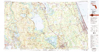
1978 Map of Daytona Beach
USGS Topo · Published 1980About this map
Lake George and the St Johns River dominate this 1970s landscape, serving as a focal point for the diverse environments of central and coastal Florida. The western half of the map is largely defined by the sprawling Ocala National Forest, where isolated settlements like Kerr City and Salt Springs sit amidst a network of smaller lakes such as Lake Kerr and Lake Bryant. To the east, the corridor between the Halifax River and the Atlantic Ocean shows the concentrated development of Daytona Beach, Ormond Beach, and Holly Hill. Between these two extremes, the terrain transitions into the wetlands of the Lake Woodruff National Wildlife Refuge. This survey captures the region just as modern infrastructure was solidifying, evidenced by the Sunshine State Parkway and established rail lines like the Florida East Coast, which parallel the coast and connect historic inland communities such as De Land and Pierson.
Find a feature on this map
92 named features on this map. Tap any name to fly to it.
Don’t see what you’re looking for? This feature index may not catch every label — zoom into the map to look around manually.
Map Details
Editions of this 1978 Daytona Beach Map
2 editions found
Other maps of this area

1893 · Panasoffkee
USGS Topo · 1:62,500

1893 · Citra
USGS Topo · 1:62,500

1895 · Citra
USGS Topo · 1:62,500

1895 · Panasoffkee
USGS Topo · 1:62,500

1895 · Ocala
USGS Topo · 1:62,500

1912 · Palatka
USGS Topo · 1:48,000

1915 · Palatka
USGS Topo · 1:62,500

1915 · Interlachen
USGS Topo · 1:48,000

1916 · Interlachen
USGS Topo · 1:62,500

1927 · Matanzas
USGS Topo · 1:48,000