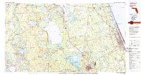
1978 Map of Daytona Beach
USGS Topo · Published 1980About this map
Lake George and the St Johns River anchor the heart of this East Florida landscape, illustrating the complex geography of the river's basin during the late 1970s. The map reveals the extensive wetlands and protected areas of the Ocala National Forest and the Lake Woodruff National Wildlife Refuge, where numerous family-named islands like Hog Island and Drayton Island dot the waterways. On the Atlantic coast, the urbanization of Daytona Beach and Ormond Beach contrasts sharply with the interior's scattered agricultural and citrus settlements.
Find a feature on this map
95 named features on this map. Tap any name to fly to it.
Don’t see what you’re looking for? This feature index may not catch every label — zoom into the map to look around manually.
Map Details
Editions of this 1978 Daytona Beach Map
2 editions found
Other maps of this area

1893 · Panasoffkee
USGS Topo · 1:62,500

1893 · Citra
USGS Topo · 1:62,500

1895 · Citra
USGS Topo · 1:62,500

1895 · Panasoffkee
USGS Topo · 1:62,500

1895 · Ocala
USGS Topo · 1:62,500

1912 · Palatka
USGS Topo · 1:48,000

1915 · Palatka
USGS Topo · 1:62,500

1915 · Interlachen
USGS Topo · 1:48,000

1916 · Interlachen
USGS Topo · 1:62,500

1927 · Matanzas
USGS Topo · 1:48,000