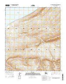
2014 Map of De Long Mountains D-4 NE
USGS Topo · Published 2014About this map
Noonuklook Mountain anchors this northern landscape, where the terrestrial terrain meets the Chukchi Sea along the Arctic coastline. The area is defined by a series of drainage systems, including the winding course of Akulik Cr and its tributaries such as Ikikileruk Cr. The topography reveals the transition from coastal lowlands to the more elevated interior highlands of the De Long Mountains. To the northeast, the waters of Tulugak Cr carve through the land, illustrating the characteristic drainage patterns of the North Slope. This 2014 survey documents the remote coastal geography and the intricate network of seasonal waterways that shape this unpopulated stretch of the Alaskan wilderness.
Find a feature on this map
9 named features on this map. Tap any name to fly to it.
Don’t see what you’re looking for? This feature index may not catch every label — zoom into the map to look around manually.
Map Details
Editions of this 2014 De Long Mountains D-4 NE Map
This is the sole edition of this map. No revisions or reprints were ever made.
Other maps of this area

1951 · De Long Mountains
USGS Topo · 1:250,000

1951 · Point Lay
USGS Topo · 1:250,000

1955 · De Long Mountains
USGS Topo · 1:250,000

1955 · Point Lay
USGS Topo · 1:250,000
1955 · Point Lay A-3 & 4
USGS Topo · 1:63,360
1955 · De Long Mountains D-3
USGS Topo · 1:63,360

1955 · De Long Mountains D-4
USGS Topo · 1:63,360

1965 · Point Lay
USGS Topo · 1:250,000

1965 · De Long Mountains
USGS Topo · 1:250,000
2014 · Point Lay A-3 SW
USGS Topo · 1:25,000