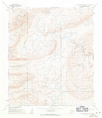
1955 Map of De Long Mountains D-3
USGS Topo · Published 1971About this map
Kukpuk Creek winds through the northwestern reaches of this 1955 survey of the De Long Mountains, highlighting a landscape defined by sharp drainage patterns and high ridges. The terrain is dominated by the headwaters of Turbid Creek, which flows through the center of the sheet, revealing the natural hydrology of the North Slope. Mapped by the U.S. Army Topographic Command, the contour lines illustrate the significant elevation changes that characterize this sub-arctic environment. Without settlements or roads present during this era, the map serves as a pure record of the natural topography and the intricate network of unnamed tributaries that feed into the larger creek systems of the region.
Find a feature on this map
2 named features on this map. Tap any name to fly to it.
Don’t see what you’re looking for? This feature index may not catch every label — zoom into the map to look around manually.
Map Details
Editions of this 1955 De Long Mountains D-3 Map
This is the sole edition of this map. No revisions or reprints were ever made.
Other maps of this area

1951 · De Long Mountains
USGS Topo · 1:250,000

1951 · Point Lay
USGS Topo · 1:250,000

1955 · De Long Mountains
USGS Topo · 1:250,000

1955 · Point Lay
USGS Topo · 1:250,000

1955 · De Long Mountains D-2
USGS Topo · 1:63,360
1955 · De Long Mountains C-2
USGS Topo · 1:63,360
1955 · Point Lay A-3 & 4
USGS Topo · 1:63,360
1955 · Point Lay A-2
USGS Topo · 1:63,360

1955 · De Long Mountains D-4
USGS Topo · 1:63,360

1955 · De Long Mountains C-4
USGS Topo · 1:63,360