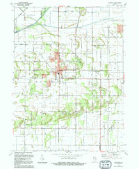
1992 Map of De Motte
USGS Topo · Published 1992About this map
The Kankakee River and its accompanying network of ditches define the landscape of northwestern Jasper County, where the town of DeMotte serves as a primary hub. This 1992 revision reflects the mid-century development of the area, including the DeMotte Airport and several residential clusters like Kersey and Wiekerville. The map provides significant detail for family historians, noting local congregations such as First Baptist Ch and St Cecilia Ch, alongside burial grounds like the Holland Cem and Lutheran Cem. Conservation efforts are visible in the Grand Kankakee Marsh County Park, preserving a segment of the historic marshlands that once dominated this region. Further south, the settlement of Kniman is situated among the gridded sections of Walker and Union townships.
Find a feature on this map
41 named features on this map. Tap any name to fly to it.
Don’t see what you’re looking for? This feature index may not catch every label — zoom into the map to look around manually.
Map Details
Editions of this 1992 De Motte Map
This is the sole edition of this map. No revisions or reprints were ever made.
Other maps of this area

1953 · Leroy
USGS Topo · 1:24,000

1953 · Hebron
USGS Topo · 1:24,000

1953 · Kouts
USGS Topo · 1:24,000

1953 · Chicago
USGS Topo · 1:250,000

1957 · Chicago
USGS Topo · 1:250,000

1957 · Wheatfield
USGS Topo · 1:24,000

1957 · DeMotte
USGS Topo · 1:24,000

1959 · Shelby
USGS Topo · 1:24,000

1962 · Gifford
USGS Topo · 1:24,000

1962 · Parr
USGS Topo · 1:24,000