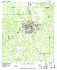
1994 Map of De Quincy
USGS Topo · Published 1996About this map
The town of De Quincy serves as the central hub of this mid-1990s survey, positioned along the border of Beauregard and Calcasieu Parishes. This landscape is defined by the extraction economy of Southwest Louisiana, illustrated by the North De Quincy Oil Field, the Perkins Oil and Gas Field, and the De Quincy Field. The industrial character of the region is further underscored by the presence of the C. Paul Phelps Correctional Center in the north and several pits scattered near the residential areas. Beyond the town grid, the terrain is marked by a network of waterways including Beckwith Creek and Buxton Creek, which drain into the Little River. Small outlying settlements such as Hargrove, Helme, and Perkins provide glimpses into the rural residential patterns of the era, while a dedicated Landing Strip and proximity to multiple Mobile Home Park sites indicate the specialized local infrastructure supporting the parish workforce.
Find a feature on this map
21 named features on this map. Tap any name to fly to it.
Don’t see what you’re looking for? This feature index may not catch every label — zoom into the map to look around manually.
Map Details
Editions of this 1994 De Quincy Map
This is the sole edition of this map. No revisions or reprints were ever made.
Other maps of this area

1935 · Buhler
USGS Topo · 1:31,680

1935 · Gordon
USGS Topo · 1:31,680

1947 · DeQuincy
USGS Topo · 1:31,680

1947 · Sulphur Mines
USGS Topo · 1:31,680

1947 · Oretta
USGS Topo · 1:31,680

1947 · Kernan
USGS Topo · 1:31,680

1947 · Hyatt
USGS Topo · 1:31,680

1947 · Lunita
USGS Topo · 1:31,680

1947 · Long Marsh
USGS Topo · 1:31,680

1949 · Kernan
USGS Topo · 1:31,680