
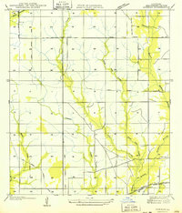
1949 Map of Kernan
USGS Topo · Published 1949About this map
Kernan sits at the intersection of a developing transportation network in Beauregard Parish, defined by the transition from earlier timber extraction to state-managed infrastructure. The landscape is heavily dissected by watercourses like Wild Cow Creek, Hickory Branch, and Cole Creek, which dictated the early layout of the region. A significant footprint of the area's industrial past is visible through the extensive Old Logging Railroad Grade, which winds through the western and central sections of the quadrangle. By the time of this field examination, the modern Missouri Pacific line and State Highway No 7 had established more permanent corridors for movement. Local life is anchored by landmarks such as Bear Ch, providing a precise point of interest for those tracing family history or early community hubs in this part of Louisiana.
Find a feature on this map
14 named features on this map. Tap any name to fly to it.
Don’t see what you’re looking for? This feature index may not catch every label — zoom into the map to look around manually.
Map Details
Editions of this 1949 Kernan Map
2 editions found
Other maps of this area

1935 · Gordon
USGS Topo · 1:31,680

1935 · Gaytine
USGS Topo · 1:31,680

1935 · Longville
USGS Topo · 1:31,680

1947 · Singer
USGS Topo · 1:31,680

1947 · Gaytine
USGS Topo · 1:31,680

1947 · DeQuincy
USGS Topo · 1:31,680

1947 · Oretta
USGS Topo · 1:31,680

1947 · Kernan
USGS Topo · 1:31,680

1947 · Longville
USGS Topo · 1:31,680

1947 · Beckwith School
USGS Topo · 1:31,680