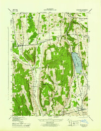
1944 Map of De Ruyter
USGS Topo · Published 1944About this map
Highland Park and the prominent De Ruyter Reservoir anchor this 1940s landscape, which spans the intersection of Onondaga, Madison, and Cortland counties. The area is defined by a series of steep ridges and creek valleys, including Stockham Hill, Arab Hill, and Morgan Hill. The village of Fabius sits in the northwest, while the southern reaches follow the various branches of Tioughnioga Creek. A dense network of small rural schoolhouses, such as School No 11 and School No 15, reflects a mid-century community structure still tied to its district origins. Transportation in the region relies on significant routes like the Skaneateles Hamilton Turnpike and the Lehigh Valley RR, which passes through the village of De Ruyter. Numerous small family and community burial grounds, including Beach Cem and Burdick Cem, are scattered across the uplands near settlements like Cowles Settlement and Gooseville Cors.
Find a feature on this map
44 named features on this map. Tap any name to fly to it.
Don’t see what you’re looking for? This feature index may not catch every label — zoom into the map to look around manually.
Map Details
Editions of this 1944 De Ruyter Map
This is the sole edition of this map. No revisions or reprints were ever made.
Other maps of this area

1897 · Cazenovia
USGS Topo · 1:62,500

1899 · Cazenovia
USGS Topo · 1:62,500

1900 · Tully
USGS Topo · 1:62,500

1903 · Cortland
USGS Topo · 1:62,500

1904 · Pitcher
USGS Topo · 1:62,500

1942 · Oran
USGS Topo · 1:24,000

1943 · Jamesville
USGS Topo · 1:31,680
1943 · Oran
USGS Topo · 1:31,680
1943 · Tully
USGS Topo · 1:24,000

1943 · De Ruyter
USGS Topo · 1:24,000