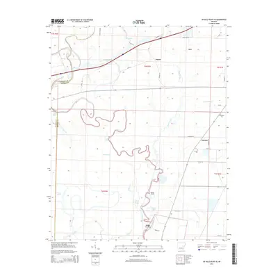
2014 Map of De Valls Bluff SE
USGS Topo · Published 2014About this map
The Cache River and Bayou De View dominate this Arkansas landscape, creating a complex network of wetlands and water bodies such as Maloy Lake and Fish Lake Slough. In this river-bottom environment, small settlements like Allendale, Dagmar, and Eden serve as anchors for the local community. The mapping of Dobbs Landing along the river and various family-named routes, including Moorehead Rd and Grizzle Rd, illustrates the reliance on specific access points within the low-lying terrain. Genealogical interest is centered near Allendale, where both Philadelphia Cem and Choctaw Cem are located. The map also captures distinctive geographic landmarks like Jones Island and Ninety Point, which provide orientation in an area defined by winding bayous and seasonal sloughs.
Find a feature on this map
45 named features on this map. Tap any name to fly to it.
Don’t see what you’re looking for? This feature index may not catch every label — zoom into the map to look around manually.
Map Details
Editions of this 2014 De Valls Bluff SE Map
This is the sole edition of this map. No revisions or reprints were ever made.
Other maps of this area

1935 · Clarendon
USGS Topo · 1:62,500

1940 · Holly Grove
USGS Topo · 1:62,500

1940 · Brinkley
USGS Topo · 1:62,500

1941 · De Valls Bluff
USGS Topo · 1:62,500

1941 · Clarendon
USGS Topo · 1:62,500

1948 · Helena
USGS Topo · 1:250,000

1950 · Helena
USGS Topo · 1:250,000

1955 · Helena
USGS Topo · 1:250,000
1957 · Clarendon
USGS Topo · 1:62,500

1957 · Holly Grove
USGS Topo · 1:62,500