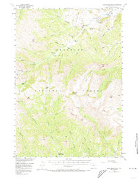
1956 Map of Dead Indian Peak
USGS Topo · Published 1973About this map
The Shoshone National Forest contains a complex network of high-elevation drainages and early 20th-century outposts as seen in this 1956 survey. The northern half of the sheet is defined by the Sunlight Mining Region, where the presence of Lee City (Aband) and Sulphur Camp points to the area's legacy of prospecting. Private landholdings are marked by distinctive family-named operations like the Quarter Circle Lazy Open A Ranch and Riddle Ranch, scattered along the banks of Sunlight Creek.
Find a feature on this map
55 named features on this map. Tap any name to fly to it.
Don’t see what you’re looking for? This feature index may not catch every label — zoom into the map to look around manually.
Map Details
Editions of this 1956 Dead Indian Peak Map
3 editions found

Other maps of this area

1893 · Ishawooa
USGS Topo · 1:125,000

1895 · Ishawooa
USGS Topo · 1:125,000

1896 · Crandall Creek
USGS Topo · 1:125,000

1899 · Crandall
USGS Topo · 1:125,000

1899 · Ishawooa
USGS Topo · 1:125,000

1949 · Pat O'Hara Mountain
USGS Topo · 1:62,500

1950 · Deep Lake
USGS Topo · 1:62,500

1955 · Cody
USGS Topo · 1:250,000

1956 · Sunlight Peak
USGS Topo · 1:62,500

1956 · Beartooth Butte
USGS Topo · 1:62,500