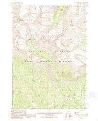
1989 Map of Dead Indian Peak
USGS Topo · Published 1989About this map
Dead Indian Peak stands as the primary landmark of this high-elevation terrain within the Shoshone National Forest. Established through fieldwork in the mid-1980s, the map delineates a remote landscape dominated by the North Absaroka Wilderness. The geography is defined by sharp drainage basins, where Dead Indian Creek and Trout Creek carve through the mountain front. A winding Pack Trail provides the only mapped route across this roadless expanse, connecting the headwaters of Big Creek with the rugged slopes of Trout Peak. The presence of The Wall and the crossing of the Wilderness Boundary reflect a land managed for its primitive character, where historical access was likely limited to seasonal hunting or high-country grazing.
Find a feature on this map
13 named features on this map. Tap any name to fly to it.
Don’t see what you’re looking for? This feature index may not catch every label — zoom into the map to look around manually.
Map Details
Editions of this 1989 Dead Indian Peak Map
This is the sole edition of this map. No revisions or reprints were ever made.
Other maps of this area

1893 · Ishawooa
USGS Topo · 1:125,000

1895 · Ishawooa
USGS Topo · 1:125,000

1896 · Crandall Creek
USGS Topo · 1:125,000

1899 · Crandall
USGS Topo · 1:125,000

1899 · Ishawooa
USGS Topo · 1:125,000

1949 · Pat O'Hara Mountain
USGS Topo · 1:62,500

1955 · Cody
USGS Topo · 1:250,000

1956 · Dead Indian Peak
USGS Topo · 1:62,500

1957 · Wapiti
USGS Topo · 1:62,500

1958 · Cody
USGS Topo · 1:250,000