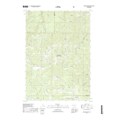
2017 Map of Deadman Mountain
USGS Topo · Published 2017About this map
Deadman Mountain and Bear Den Mtn dominate this 2017 survey of the Black Hills high country. Much of the terrain falls within the Black Hills National Forest, where a network of forest roads and trails, including Lost Gulch Br 1F and Calamity Canyon 8043, winds through deep ravines and gulches. The landscape is defined by its verticality, from the high peaks of Flagstaff Mtn to the depths of Little Elk Canyon and Virkula Gulch. Water is central to the area's geography, with the Sturgis Reservoirs and Reausaw Lake providing significant landmarks among the timbered ridges. Named summits like Red Hill and Kirk Hill suggest early settlement patterns or family-named landmarks in this Lawrence and Meade County borderland. The intricate mapping of seasonal drainages such as Bear Butte Cr and Alkali Cr highlights the complex watershed system of this South Dakota wilderness.
Find a feature on this map
96 named features on this map. Tap any name to fly to it.
Don’t see what you’re looking for? This feature index may not catch every label — zoom into the map to look around manually.
Map Details
Editions of this 2017 Deadman Mountain Map
This is the sole edition of this map. No revisions or reprints were ever made.
Other maps of this area

1893 · Rapid
USGS Topo · 1:125,000

1894 · Deadwood
USGS Topo · 1:125,000

1898 · Rapid
USGS Topo · 1:125,000

1899 · Sturgis
USGS Topo · 1:62,500

1901 · Deadwood
USGS Topo · 1:125,000

1903 · Rapid
USGS Topo · 1:125,000

1915 · Sturgis
USGS Topo · 1:62,500

1916 · Deadwood
USGS Topo · 1:125,000

1953 · Piedmont
USGS Topo · 1:24,000
1953 · Fort Meade
USGS Topo · 1:24,000