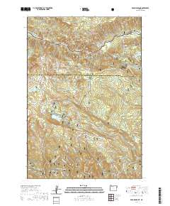
2020 Map of Deadman Point
USGS Topo · Published 2020About this map
The Imnaha Wild and Scenic River carves through the high country of the Wallowa National Forest and Whitman National Forest in this Baker County survey. High-elevation water management is evident in the man-made infrastructure of the Buchanan Ditch and Greener Ditch, which redirect snowmelt across the timbered slopes. Notable peaks and landmarks including Russel Mtn, Gobblers Knob, and Deadman Point define the local topography, while the Imnaha Falls marks a significant hydrological feature of the Imnaha River. The area is characterized by seasonal access and recreation, as shown by the extensive network of the Fish Lake Snowmobile trail and the Duck Lake Cutoff. Significant water bodies like Sugarloaf Reservoir, Lost Lake Reservoir, and Fish Lake are interspersed throughout the wooded canyons and basins.
Find a feature on this map
67 named features on this map. Tap any name to fly to it.
Don’t see what you’re looking for? This feature index may not catch every label — zoom into the map to look around manually.
Map Details
Editions of this 2020 Deadman Point Map
This is the sole edition of this map. No revisions or reprints were ever made.
Other maps of this area

1915 · Pine
USGS Topo · 1:125,000

1954 · Cornucopia
USGS Topo · 1:62,500

1955 · Baker
USGS Topo · 1:250,000

1955 · Grangeville
USGS Topo · 1:250,000

1957 · Halfway
USGS Topo · 1:62,500

1957 · Homestead
USGS Topo · 1:62,500

1957 · Copperfield
USGS Topo · 1:62,500

1959 · Baker
USGS Topo · 1:250,000

1959 · Grangeville
USGS Topo · 1:250,000

1980 · McCall
USGS Topo · 1:100,000