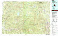
1982 Map of Deadwood River
USGS Topo · Published 1982About this map
The Salmon River Mountains and the Sawtooth Range dominate this 1982 survey of central Idaho, a landscape defined by the drainage basins of the North Fork, Middle Fork, and South Fork Payette Rivers. In the southwest corner, the small communities of Garden Valley, Crouch, and Lowman serve as the primary human outposts before the terrain rises into the protected wilderness areas. The map details the central role of water management and aviation in this backcountry, centering on the Deadwood Reservoir and remote infrastructure like the Bruce Meadows and Warm Springs Landing Strip for access into the interior.
Find a feature on this map
135 named features on this map. Tap any name to fly to it.
Don’t see what you’re looking for? This feature index may not catch every label — zoom into the map to look around manually.
Map Details
Editions of this 1982 Deadwood River Map
This is the sole edition of this map. No revisions or reprints were ever made.
Other maps of this area

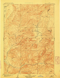
1891 · Bear Valley
USGS Topo · 1:125,000

1892 · Boise
USGS Topo · 1:125,000

1893 · Bear Valley
USGS Topo · 1:125,000

1894 · Squaw Creek
USGS Topo · 1:125,000

1894 · Idaho Basin
USGS Topo · 1:125,000

1894 · Rocky Bar
USGS Topo · 1:125,000

1897 · Boise
USGS Topo · 1:125,000

1900 · Sawtooth
USGS Topo · 1:125,000
1909 · Garden Valley
USGS Topo · 1:125,000

1911 · Meadows
USGS Topo · 1:125,000