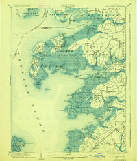
1903 Map of Deal Island
USGS Topo · Published 1927About this map
Deal Island and the surrounding Chesapeake marshlands define this turn-of-the-century coastal survey. The map details a landscape deeply connected to the water, where settlements like Wenona and Chance cling to the narrow strips of dry ground between Tangier Sound and the intricate wetlands of Dames Quarter. This era shows a robust maritime and agricultural economy, evidenced by maritime aids such as Great Shoals L.H. and the terminal reach of the N.Y.P. and N. R. R. (Crisfield Br.) at Marion. Further inland, the map captures the community structure of Upper Fairmount, Landonville, and Oriole, while the northern reaches follow the Nanticoke River and Monie Bay. The layout of local wharves, such as Fords Wharf, and family-named landmarks like Tulls Corner provide specific points of interest for those tracing the development of Somerset and Wicomico counties.
Find a feature on this map
124 named features on this map. Tap any name to fly to it.
Don’t see what you’re looking for? This feature index may not catch every label — zoom into the map to look around manually.
Map Details
Editions of this 1903 Deal Island Map
3 editions found
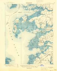
Other maps of this area

1898 · St. Marys
USGS Topo · 1:125,000

1901 · Salisbury
USGS Topo · 1:62,500

1903 · Crisfield
USGS Topo · 1:62,500

1903 · Nanticoke
USGS Topo · 1:62,500

1903 · Bloodsworth Island
USGS Topo · 1:62,500

1903 · Deal Island
USGS Topo · 1:62,500

1905 · Crapo
USGS Topo · 1:62,500

1906 · St. Marys
USGS Topo · 1:125,000
1917 · Ewell
USGS Topo · 1:62,500

1920 · Crisfield
USGS Topo · 1:62,500