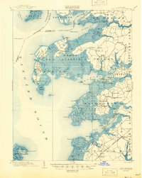
1903 Map of Deal Island
USGS Topo · Published 1944About this map
Deal Island and the intricate marshlands of the Tangier Sound dominate this coastal survey of Somerset and Wicomico counties. The landscape is defined by the complex water systems of the Nanticoke River and Monie Bay, where small fishing settlements like Wenona and Chance cling to the low-lying shoreline. Inland, the arrival of the N. Y. P. and N. R. R. (Crisfield Br.) indicates the vital rail connection that linked this maritime economy to northern markets. Settlements such as Upper Fairmount, Oriole, and Tulls Corner serve as central hubs for the surrounding farm and marsh districts. Navigation throughout these shifting shoals is marked by the Great Shoals L.H. and Sharkfin Shoal L.H., critical infrastructure for the watermen of the era. The map reveals a high level of detail for genealogists, including the precise locations of rural centers like St. Stephen and Landonville.
Find a feature on this map
127 named features on this map. Tap any name to fly to it.
Don’t see what you’re looking for? This feature index may not catch every label — zoom into the map to look around manually.
Map Details
Editions of this 1903 Deal Island Map
3 editions found
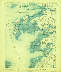
Other maps of this area

1898 · St. Marys
USGS Topo · 1:125,000

1901 · Salisbury
USGS Topo · 1:62,500

1903 · Crisfield
USGS Topo · 1:62,500

1903 · Nanticoke
USGS Topo · 1:62,500

1903 · Bloodsworth Island
USGS Topo · 1:62,500

1903 · Deal Island
USGS Topo · 1:62,500

1905 · Crapo
USGS Topo · 1:62,500

1906 · St. Marys
USGS Topo · 1:125,000

1917 · Ewell
USGS Topo · 1:62,500

1920 · Crisfield
USGS Topo · 1:62,500