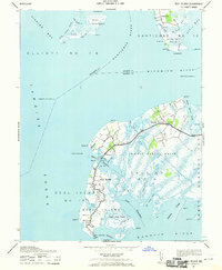
1942 Map of Deal Island
USGS Topo · Published 1970About this map
Deal Island and the neighboring settlements of Wenona, Chance, and Dames Quarter dominate this 1942 survey of the Somerset County coastline. The landscape is defined by an intricate network of tidal guts and thorofares, such as Laws Thorofare and Lower Thorofare, which historically facilitated the local waterborne economy and navigation. Located at the confluence of the Nanticoke River, Wicomico River, and Tangier Sound, this area was critical for Chesapeake Bay maritime traffic, marked by landmarks like the Sharkfin Shoal Lighthouse and Great Shoals Lighthouse. The map illustrates a rural, coastal pattern of life where housing and industry are tightly clustered along the primary road, now known as 363, surrounded by expansive wetlands like Dames Quarter Marsh. Genealogists will find interest in the specific placement of village structures and the many named landing points and guts that defined family property and livelihoods in the mid-20th century.
Find a feature on this map
71 named features on this map. Tap any name to fly to it.
Don’t see what you’re looking for? This feature index may not catch every label — zoom into the map to look around manually.
Map Details
Editions of this 1942 Deal Island Map
2 editions found

Other maps of this area

1898 · St. Marys
USGS Topo · 1:125,000

1903 · Nanticoke
USGS Topo · 1:62,500

1903 · Bloodsworth Island
USGS Topo · 1:62,500

1903 · Deal Island
USGS Topo · 1:62,500

1905 · Crapo
USGS Topo · 1:62,500

1906 · St. Marys
USGS Topo · 1:125,000

1942 · Terrapin Sand Point
USGS Topo · 1:24,000

1942 · Kedges Straits
USGS Topo · 1:24,000

1942 · Bloodsworth Island
USGS Topo · 1:24,000

1942 · Marion
USGS Topo · 1:24,000