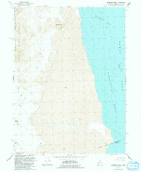
1991 Map of Deardens Knoll
USGS Topo · Published 1991About this map
The eastern foothills of the Lakeside Mountains meet the shifting shoreline of the Great Salt Lake in this 1991 revision of the western desert. Dominating the landscape is the Utah Test and Training Range, which covers the rugged interior terrain of the North Range and includes prominent peaks like Sally Mtn. The map highlights the transition from these upland ranges to the expansive Mud flats that border Gilbert Bay and Carrington Bay. Local geographic landmarks such as Deardens Knoll and Richins Knoll provide points of reference in an otherwise sparsely settled environment. Sparse infrastructure, including a Pipeline and various 4wd tracks, underscores the area's primary use for military operations and resource management. The map also delineates the Indefinite Boundary along the lake shore, reflecting the variable water levels characteristic of this region.
Find a feature on this map
15 named features on this map. Tap any name to fly to it.
Don’t see what you’re looking for? This feature index may not catch every label — zoom into the map to look around manually.
Map Details
Editions of this 1991 Deardens Knoll Map
This is the sole edition of this map. No revisions or reprints were ever made.
Other maps of this area

1885 · Tooele Valley
USGS Topo · 1:250,000

1953 · Tooele
USGS Topo · 1:250,000

1954 · Brigham City
USGS Topo · 1:250,000

1955 · Tooele
USGS Topo · 1:250,000

1958 · Brigham City
USGS Topo · 1:250,000

1962 · Brigham City
USGS Topo · 1:250,000

1968 · Carrington Island SW
USGS Topo · 1:24,000

1968 · Deardens Knoll
USGS Topo · 1:24,000

1968 · Badger Island NW
USGS Topo · 1:24,000

1968 · Craner Peak
USGS Topo · 1:24,000