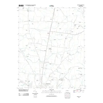
2010 Map of Deason
USGS Topo · Published 2010About this map
Shelbyville and its northern rural environs are defined by a dense network of family cemeteries and small creek valleys in this 2010 topographic study. The landscape is notably marked by ancestral burial grounds such as the Erwin Slave Cemetery, Houston Whitworth Cemetery, and Springer Cemetery, reflecting generations of local land ownership and lineage. Transportation is centered around Bomar Field-Shelbyville Municipal Airport, while the terrain rises toward significant landmarks like Horse Mountain and the Epps Hills to the northeast. Water follows the natural drainage of Hurricane Creek, Fall Creek, and the Little Hurricane Creek, which carve through the farmland between major thoroughfares like the Old Nashville Dirt Rd. This survey documents the transition between the urban reach of Shelbyville and the enduring pastoral character of Bedford County.
Find a feature on this map
98 named features on this map. Tap any name to fly to it.
Don’t see what you’re looking for? This feature index may not catch every label — zoom into the map to look around manually.
Map Details
Editions of this 2010 Deason Map
This is the sole edition of this map. No revisions or reprints were ever made.
Other maps of this area

1936 · Webbs Jungle
USGS Topo · 1:24,000

1936 · Shelbyville
USGS Topo · 1:24,000

1936 · Rover
USGS Topo · 1:24,000

1936 · Deason
USGS Topo · 1:24,000

1936 · Wartrace
USGS Topo · 1:24,000

1936 · Unionville
USGS Topo · 1:24,000

1936 · Bedford
USGS Topo · 1:24,000

1936 · Normandy
USGS Topo · 1:24,000

1936 · Fosterville
USGS Topo · 1:24,000

1944 · Shelbyville
USGS Topo · 1:100,000