
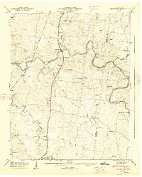
1936 Map of Unionville
USGS Topo · Published 1936About this map
The Duck River winds through this rural section of Bedford County, shaping a landscape defined by water-powered industry and dispersed agricultural communities. In the mid-1930s, several small milling sites still marked the river and its tributaries, including Blackburns Mill, Halls Mill, and Anchor Mill, which stand as evidence of the area's local grain-processing economy. Settlement patterns follow the high ground between the forks, with Unionville serving as a primary hub alongside smaller junctions like Poplins Crossroads.
Find a feature on this map
66 named features on this map. Tap any name to fly to it.
Don’t see what you’re looking for? This feature index may not catch every label — zoom into the map to look around manually.
Map Details
Editions of this 1936 Unionville Map
This is the sole edition of this map. No revisions or reprints were ever made.
Other maps of this area

1936 · Chapel Hill
USGS Topo · 1:24,000

1936 · Farmington
USGS Topo · 1:24,000

1936 · Shelbyville
USGS Topo · 1:24,000

1936 · Rover
USGS Topo · 1:24,000

1936 · Belfast
USGS Topo · 1:24,000

1936 · Deason
USGS Topo · 1:24,000

1936 · Bedford
USGS Topo · 1:24,000

1936 · Fosterville
USGS Topo · 1:24,000

1944 · Shelbyville
USGS Topo · 1:100,000
1947 · Farmington
USGS Topo · 1:24,000