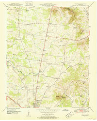
1951 Map of Deason
USGS Topo · Published 1951About this map
Shelbyville serves as the southern anchor of this Tennessee landscape, where the Florida Short Route and Midland Pike connect rural communities across the rolling countryside of Bedford and Rutherford counties. The terrain is defined by the Tennessee Valley Divide and prominent elevations like Horse Mountain and Mingle Hill. The map reveals a dense network of family heritage markers, with numerous small burial grounds such as Houston-Whitworth Cemetery and Mespurvis Cemetery scattered near waterways like Hurricane Creek and Fall Creek.
Find a feature on this map
80 named features on this map. Tap any name to fly to it.
Don’t see what you’re looking for? This feature index may not catch every label — zoom into the map to look around manually.
Map Details
Editions of this 1951 Deason Map
This is the sole edition of this map. No revisions or reprints were ever made.
Other maps of this area

1936 · Webbs Jungle
USGS Topo · 1:24,000

1936 · Shelbyville
USGS Topo · 1:24,000

1936 · Rover
USGS Topo · 1:24,000

1936 · Deason
USGS Topo · 1:24,000

1936 · Wartrace
USGS Topo · 1:24,000

1936 · Unionville
USGS Topo · 1:24,000

1936 · Bedford
USGS Topo · 1:24,000

1936 · Normandy
USGS Topo · 1:24,000

1936 · Fosterville
USGS Topo · 1:24,000

1944 · Shelbyville
USGS Topo · 1:100,000