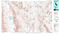
1986 Map of Death Valley Junction
USGS Topo · Published 1986About this map
Death Valley and its surrounding desert basins dominate this mid-1980s topographical survey, revealing a landscape defined by extreme elevations and mineral history. The Badwater Basin and the salt-encrusted flats of the Devils Golf Course sit at the foot of the Black Mountains, while the former narrow-gauge tracks of the T & T RR trace a historic path through the Amargosa Desert.
Find a feature on this map
64 named features on this map. Tap any name to fly to it.
Don’t see what you’re looking for? This feature index may not catch every label — zoom into the map to look around manually.
Map Details
Editions of this 1986 Death Valley Junction Map
2 editions found
Other maps of this area

1907 · Las Vegas
USGS Topo · 1:250,000

1908 · Furnace Creek
USGS Topo · 1:250,000

1908 · Las Vegas
USGS Topo · 1:250,000

1908 · Ballarat
USGS Topo · 1:250,000

1910 · Furnace Creek
USGS Topo · 1:250,000

1910 · Ivanpah
USGS Topo · 1:250,000

1912 · Ivanpah
USGS Topo · 1:250,000

1913 · Ballarat
USGS Topo · 1:250,000

1915 · Searles Lake
USGS Topo · 1:250,000

1933 · Avawatz Mountains
USGS Topo · 1:250,000