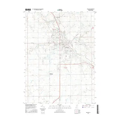
2016 Map of Decatur
USGS Topo · Published 2016About this map
The Saint Marys River meanders through the heart of Decatur, anchoring a landscape defined by an intricate network of agricultural drainage canals such as Ohler Ditch and Hessler Ditch. This 2016 survey shows the town’s modern grid intersecting with long-established rural routes like Winchester Rd and Mercer Ave. To the north, the small settlement of Monmouth sits near the riverbanks, while Elm Tree Crossroads marks a distinct point in the southern township. Local history is preserved in several community grounds, including Greenwood Cem and Saint Josephs Cem. The presence of Gage Airport and several industrial parcels reflects the contemporary economic character of Adams County, contrasting with the surrounding persistent farmstead layout and natural features like Saddle Lake and Borum Run.
Find a feature on this map
52 named features on this map. Tap any name to fly to it.
Don’t see what you’re looking for? This feature index may not catch every label — zoom into the map to look around manually.
Map Details
Editions of this 2016 Decatur Map
This is the sole edition of this map. No revisions or reprints were ever made.
Other maps of this area

1911 · Berne
USGS Topo · 1:48,000

1953 · Muncie
USGS Topo · 1:250,000

1956 · Muncie
USGS Topo · 1:250,000

1960 · Dixon
USGS Topo · 1:24,000
1960 · Wren
USGS Topo · 1:24,000
1960 · Willshire
USGS Topo · 1:24,000

1961 · Hoagland
USGS Topo · 1:24,000

1962 · Poe
USGS Topo · 1:24,000

1962 · Preble
USGS Topo · 1:24,000

1962 · Berne
USGS Topo · 1:24,000