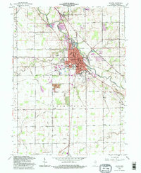
1992 Map of Decatur
USGS Topo · Published 1995About this map
The St Marys River winds through the heart of this landscape, anchoring the city of Decatur as it sits at the junction of the Norfolk and Western railroad and several historic regional routes like Piqua Road and Winchester Road. This 1992 revision reveals a well-established civic center featuring a Courthouse, Library, and County Hospital, surrounded by an extensive network of drainage ditches such as Ohler Ditch and Weber Ditch that transformed the prairie into productive farmland. Genealogists will find significant value in the numerous documented burial sites and rural congregations, including St Josephs Cemetery, Union Chapel Cem, and Mt Pleasant Ch. From the industrial Kilns near the city center to the outlying County Home and the small settlement at Monmouth, the map provides a look at the intersection of local industry and rural Adams County life.
Find a feature on this map
64 named features on this map. Tap any name to fly to it.
Don’t see what you’re looking for? This feature index may not catch every label — zoom into the map to look around manually.
Map Details
Editions of this 1992 Decatur Map
This is the sole edition of this map. No revisions or reprints were ever made.
Other maps of this area

1911 · Berne
USGS Topo · 1:48,000

1953 · Muncie
USGS Topo · 1:250,000

1956 · Muncie
USGS Topo · 1:250,000

1960 · Dixon
USGS Topo · 1:24,000
1960 · Wren
USGS Topo · 1:24,000
1960 · Willshire
USGS Topo · 1:24,000

1961 · Hoagland
USGS Topo · 1:24,000

1962 · Poe
USGS Topo · 1:24,000

1962 · Preble
USGS Topo · 1:24,000

1962 · Berne
USGS Topo · 1:24,000