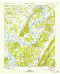
1942 Map of Decatur
USGS Topo · Published 1962About this map
The Tennessee River dominates this 1942 landscape as it undergoes a massive industrial and hydroelectric transformation. The recently completed Watts Bar Dam and the Watts Bar Steam Plant appear alongside the expansive waters of Chickamauga Lake, marking the era of the Tennessee Valley Authority’s influence on local geography. While the river became a series of reservoirs, older transportation patterns like the Pinhook Ferry and river landings such as Sewee Landing and Vineyard Landing remain visible, anchoring the community to its riverbank roots.
Find a feature on this map
81 named features on this map. Tap any name to fly to it.
Don’t see what you’re looking for? This feature index may not catch every label — zoom into the map to look around manually.
Map Details
Editions of this 1942 Decatur Map
2 editions found
Other maps of this area

1886 · Cleveland
USGS Topo · 1:125,000

1887 · Kingston
USGS Topo · 1:125,000

1891 · Kingston
USGS Topo · 1:125,000

1892 · Cleveland
USGS Topo · 1:125,000

1893 · Kingston
USGS Topo · 1:125,000

1895 · Cleveland
USGS Topo · 1:125,000

1901 · Cleveland
USGS Topo · 1:125,000

1935 · Goodfield
USGS Topo · 1:24,000

1935 · Evensville
USGS Topo · 1:24,000

1935 · Decatur
USGS Topo · 1:24,000