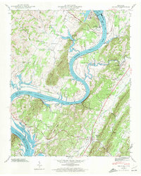
1942 Map of Decatur
USGS Topo · Published 1972About this map
Decatur serves as the focal point of this Tennessee River valley landscape, captured as the regional environment was being transformed by major infrastructure projects. The map documents the immense scale of the Watts Bar Dam and the adjacent Watts Bar Steam Plant along the Tennessee River. These developments created Watts Bar Lake and Chickamauga Lake, altering the river's original course and submerging land near Hunter Island.
Find a feature on this map
72 named features on this map. Tap any name to fly to it.
Don’t see what you’re looking for? This feature index may not catch every label — zoom into the map to look around manually.
Map Details
Editions of this 1942 Decatur Map
2 editions found
Other maps of this area

1886 · Cleveland
USGS Topo · 1:125,000

1887 · Kingston
USGS Topo · 1:125,000

1891 · Kingston
USGS Topo · 1:125,000

1892 · Cleveland
USGS Topo · 1:125,000

1893 · Kingston
USGS Topo · 1:125,000

1895 · Cleveland
USGS Topo · 1:125,000

1901 · Cleveland
USGS Topo · 1:125,000

1935 · Goodfield
USGS Topo · 1:24,000

1935 · Evensville
USGS Topo · 1:24,000

1935 · Decatur
USGS Topo · 1:24,000