
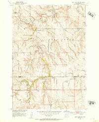
1952 Map of Deep Creek SE
USGS Topo · Published 1952About this map
The Perkins Co Meade Co border divides this 1950s landscape, illustrating the remote ranching and grazing territory of western South Dakota. Part of a larger program for the development of the Missouri River Basin, the map details a complex drainage system led by Deep Creek. The terrain is defined by the confluence of watercourses such as Flint Creek and Flint Rock Creek, which carve through the high plains. A solitary Windmill stands as a marker of the agricultural infrastructure required to sustain livestock in this semi-arid environment during the early post-war era. The survey captures the land shortly after aerial photography was conducted in 1948, reflecting a period when geographic precision was being applied to the vast open ranges of the Great Plains.
Find a feature on this map
6 named features on this map. Tap any name to fly to it.
Don’t see what you’re looking for? This feature index may not catch every label — zoom into the map to look around manually.
Map Details
Editions of this 1952 Deep Creek SE Map
2 editions found
Other maps of this area

1951 · Deep Creek NW
USGS Topo · 1:24,000

1952 · Signal Butte
USGS Topo · 1:24,000

1952 · Deep Creek NE
USGS Topo · 1:24,000

1952 · Faith NW
USGS Topo · 1:24,000

1953 · Rapid City
USGS Topo · 1:250,000

1954 · Lemmon
USGS Topo · 1:250,000

1957 · Lemmon
USGS Topo · 1:250,000

1957 · Rapid City
USGS Topo · 1:250,000

1983 · Lemmon Butte
USGS Topo · 1:24,000
1983 · Avance
USGS Topo · 1:24,000