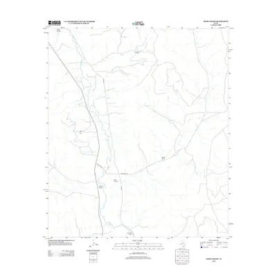
2012 Map of Deer Canyon
USGS Topo · Published 2012About this map
The Pecos River carves through this West Texas landscape, serving as the primary drainage for a network of ephemeral watercourses including Eagle Draw, Sixmile Draw, and Fourmile Draw. The terrain is defined by dramatic relief in the northwest at Riffle Canyon, while the central portion is marked by the namesake Deer Canyon. This 2012 survey illustrates the intersection of natural topography and industrial activity, specifically the energy extraction occurring at the Noelke Oil Field and the Millard Oil Field. A sparse network of local thoroughfares, such as River Rd, Texas Rock Rd, and Deer Canyon Rd, provides the only access through this arid environment, revealing how the modern oil economy utilizes the existing draws and canyons of Pecos County for infrastructure placement.
Find a feature on this map
11 named features on this map. Tap any name to fly to it.
Don’t see what you’re looking for? This feature index may not catch every label — zoom into the map to look around manually.
Map Details
Editions of this 2012 Deer Canyon Map
This is the sole edition of this map. No revisions or reprints were ever made.
Other maps of this area

1929 · Sheffield
USGS Topo · 1:125,000

1954 · Sonora
USGS Topo · 1:250,000

1958 · Sonora
USGS Topo · 1:250,000

1967 · Twelvemile Camp
USGS Topo · 1:24,000

1967 · Divide Country
USGS Topo · 1:24,000

1967 · Sheffield NW
USGS Topo · 1:24,000

1967 · Deer Canyon
USGS Topo · 1:24,000

1967 · Fort Lancaster
USGS Topo · 1:24,000
1967 · Iraan
USGS Topo · 1:24,000
1967 · Owens Creek SW
USGS Topo · 1:24,000