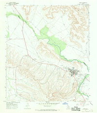
1967 Map of Iraan
USGS Topo · Published 1970About this map
The Yates Oil Field dominates this 1960s landscape, illustrating the industrial infrastructure of West Texas oil production near the town of Iraan. Numerous drill holes, a Gas Plant, and several pumping stations are spread across the terrain, connected by a network of pipelines and Private roads. The town itself is shown in detail, featuring the Municipal Airport, a Golf Course, and localized amenities like a Park and Water Tanks.
Find a feature on this map
20 named features on this map. Tap any name to fly to it.
Don’t see what you’re looking for? This feature index may not catch every label — zoom into the map to look around manually.
Map Details
Editions of this 1967 Iraan Map
This is the sole edition of this map. No revisions or reprints were ever made.
Other maps of this area

1928 · Crane
USGS Topo · 1:125,000

1928 · Rankin
USGS Topo · 1:125,000

1929 · Sheffield
USGS Topo · 1:125,000

1929 · Independence Draw Quadrangle
USGS Topo · 1:125,000

1954 · Pecos
USGS Topo · 1:250,000

1954 · Fort Stockton
USGS Topo · 1:250,000

1954 · Sonora
USGS Topo · 1:250,000

1954 · San Angelo
USGS Topo · 1:250,000

1957 · Pecos
USGS Topo · 1:250,000

1958 · Sonora
USGS Topo · 1:250,000