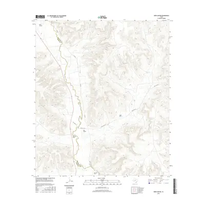
2016 Map of Deer Canyon
USGS Topo · Published 2016About this map
The Pecos River serves as the defining boundary between Pecos and Crockett counties in this West Texas survey. The terrain is marked by a complex system of drainage features, including the eponymous Deer Canyon and several named tributaries such as Eagle Draw, Sixmile Draw, and Fourmile Draw. Transportation in this arid region is largely defined by routes that parallel the water, notably River Rd and the state highway 349, which weave through the high ground above the river valley. The map documents a landscape of dramatic elevation changes, from the depths of Riffle Canyon to the mesas accessed by local tracks like Deer Canyon Rd and Texas Rock Rd.
Find a feature on this map
13 named features on this map. Tap any name to fly to it.
Don’t see what you’re looking for? This feature index may not catch every label — zoom into the map to look around manually.
Map Details
Editions of this 2016 Deer Canyon Map
This is the sole edition of this map. No revisions or reprints were ever made.
Other maps of this area

1929 · Sheffield
USGS Topo · 1:125,000

1954 · Sonora
USGS Topo · 1:250,000

1958 · Sonora
USGS Topo · 1:250,000

1967 · Twelvemile Camp
USGS Topo · 1:24,000

1967 · Divide Country
USGS Topo · 1:24,000

1967 · Sheffield NW
USGS Topo · 1:24,000

1967 · Deer Canyon
USGS Topo · 1:24,000

1967 · Fort Lancaster
USGS Topo · 1:24,000
1967 · Iraan
USGS Topo · 1:24,000
1967 · Owens Creek SW
USGS Topo · 1:24,000