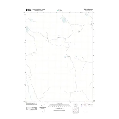
2011 Map of Deer Lake
USGS Topo · Published 2011About this map
Blue Creek meanders through the southwest corner of this Garden County landscape, a region defined by its characteristic sandhill depressions and isolated water bodies. The terrain is marked by a series of distinct valleys, likely reflecting old homesteading or grazing divisions, including Meeker Valley, Swede Valley, and Campbell Valley. These landforms, along with Red Kate Valley, suggest a history of family-named cattle ranching operations common to this part of Nebraska. Scattered lakes provide critical water sources in an otherwise arid environment, ranging from the central Deer Lake and Swede Lake to the more remote Cross Lake and Christ Lake in the north. The network of light-duty roads and trails connecting these points illustrates the sparse but persistent infrastructure required for modern range management and navigation in the heart of the Sandhills.
Find a feature on this map
14 named features on this map. Tap any name to fly to it.
Don’t see what you’re looking for? This feature index may not catch every label — zoom into the map to look around manually.
Map Details
Editions of this 2011 Deer Lake Map
This is the sole edition of this map. No revisions or reprints were ever made.
Other maps of this area

1949 · Mumper
USGS Topo · 1:62,500

1949 · Rackett
USGS Topo · 1:62,500

1950 · Crescent Lake
USGS Topo · 1:62,500

1950 · Longfellow Lake
USGS Topo · 1:62,500

1951 · Rackett
USGS Topo · 1:62,500

1954 · Scottsbluff
USGS Topo · 1:250,000

1958 · Scottsbluff
USGS Topo · 1:250,000

1985 · Crescent Lake
USGS Topo · 1:100,000
1986 · Gusher Spring
USGS Topo · 1:24,000
1986 · Sugar Loaf Hill
USGS Topo · 1:24,000