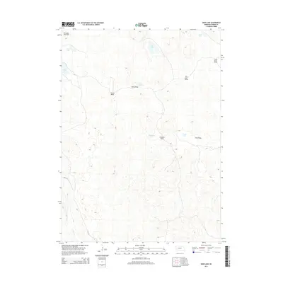
2014 Map of Deer Lake
USGS Topo · Published 2014About this map
Old Lady Beam Hill stands as a prominent landmark in this section of Garden County, where the Sandhills landscape is defined by a dense network of interdunal valleys and isolated lakes. This 2014 survey by the U.S. Geological Survey illustrates a traditional ranching geography where land features often bear the names of early settlers or local families. Natural depressions in the terrain are occupied by numerous water bodies, including Deer Lake, Swede Lake, and the smaller Cross Lake to the north. These basins are interconnected by named lowlands such as Meeker Valley, Red Kate Valley, and Swede Valley, which provide natural corridors through the rolling topography. Human infrastructure is minimal, represented primarily by Road 181 in the southwest and a few scattered local connectors that navigate the gaps between lakes like Campbell Lake and Camp Lake.
Find a feature on this map
16 named features on this map. Tap any name to fly to it.
Don’t see what you’re looking for? This feature index may not catch every label — zoom into the map to look around manually.
Map Details
Editions of this 2014 Deer Lake Map
This is the sole edition of this map. No revisions or reprints were ever made.
Other maps of this area

1949 · Mumper
USGS Topo · 1:62,500

1949 · Rackett
USGS Topo · 1:62,500

1950 · Crescent Lake
USGS Topo · 1:62,500

1950 · Longfellow Lake
USGS Topo · 1:62,500

1951 · Rackett
USGS Topo · 1:62,500

1954 · Scottsbluff
USGS Topo · 1:250,000

1958 · Scottsbluff
USGS Topo · 1:250,000

1985 · Crescent Lake
USGS Topo · 1:100,000
1986 · Gusher Spring
USGS Topo · 1:24,000
1986 · Sugar Loaf Hill
USGS Topo · 1:24,000