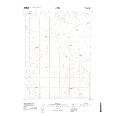
2017 Map of Deer Lake
USGS Topo · Published 2017About this map
Deer Lake and a series of ephemeral water bodies define the interior of this Garden County landscape, where the topography is shaped by a dense network of valleys. These depressions, including Meeker Valley, Swede Valley, and Red Kate Valley, suggest a geographic pattern where seasonal or permanent lakes collect in the low-lying reaches of the Sandhills. The presence of Swede Lake and Christ Lake alongside these named valleys highlights a legacy of local naming traditions tied to the specific hydrology of the region.
Find a feature on this map
21 named features on this map. Tap any name to fly to it.
Don’t see what you’re looking for? This feature index may not catch every label — zoom into the map to look around manually.
Map Details
Editions of this 2017 Deer Lake Map
This is the sole edition of this map. No revisions or reprints were ever made.
Other maps of this area

1949 · Mumper
USGS Topo · 1:62,500

1949 · Rackett
USGS Topo · 1:62,500

1950 · Crescent Lake
USGS Topo · 1:62,500

1950 · Longfellow Lake
USGS Topo · 1:62,500

1951 · Rackett
USGS Topo · 1:62,500

1954 · Scottsbluff
USGS Topo · 1:250,000

1958 · Scottsbluff
USGS Topo · 1:250,000

1985 · Crescent Lake
USGS Topo · 1:100,000
1986 · Gusher Spring
USGS Topo · 1:24,000
1986 · Sugar Loaf Hill
USGS Topo · 1:24,000