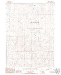
1986 Map of Deer Lake
USGS Topo · Published 1986About this map
Crescent Lake National Wildlife Refuge dominates this section of the Nebraska Sandhills, preserved as a vast wetland complex within the high plains. The landscape is characterized by numerous alkaline and freshwater basins, including the namesake Deer Lake, along with Crane Lake, Christ Lake, and Swede Lake. These water bodies are nestled among rolling dunes and named depressions like Meeker Valley and Red Kate Valley, illustrating the unique topography of Garden County.
Find a feature on this map
17 named features on this map. Tap any name to fly to it.
Don’t see what you’re looking for? This feature index may not catch every label — zoom into the map to look around manually.
Map Details
Editions of this 1986 Deer Lake Map
This is the sole edition of this map. No revisions or reprints were ever made.
Other maps of this area

1949 · Mumper
USGS Topo · 1:62,500

1949 · Rackett
USGS Topo · 1:62,500

1950 · Crescent Lake
USGS Topo · 1:62,500

1950 · Longfellow Lake
USGS Topo · 1:62,500

1951 · Rackett
USGS Topo · 1:62,500

1954 · Scottsbluff
USGS Topo · 1:250,000

1958 · Scottsbluff
USGS Topo · 1:250,000

1985 · Crescent Lake
USGS Topo · 1:100,000
1986 · Gusher Spring
USGS Topo · 1:24,000
1986 · Sugar Loaf Hill
USGS Topo · 1:24,000