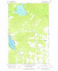
1965 Map of Deer Lake
USGS Topo · Published 1978About this map
Deer Lake and Loon Lake dominate this mid-century landscape in the southern reaches of Stevens County, situated just north of the Spokane County line. The terrain is defined by prominent peaks including Deer Lake Mountain and Blue Grouse Mtn, while the lowlands are drained by Beaver Creek and Dragoon Creek. Industrial activity of the era is evident through several extractive sites, such as the Little King Mines and numerous gravel and clay pits scattered near the water bodies. Transportation through the valley relies on the Burlington Northern railroad corridor, which skirts the western edge of the lake. Local landmarks like Zion Hill Cem and a Gaging Station on the shoreline provide specific points of interest for genealogists and researchers mapping the historical development of these recreational and resource-rich highlands.
Find a feature on this map
27 named features on this map. Tap any name to fly to it.
Don’t see what you’re looking for? This feature index may not catch every label — zoom into the map to look around manually.
Map Details
Editions of this 1965 Deer Lake Map
3 editions found
Other maps of this area

1901 · Spokane
USGS Topo · 1:125,000

1927 · Chewelah
USGS Topo · 1:125,000

1930 · Chewelah
USGS Topo · 1:125,000

1936 · Newport
USGS Topo · 1:96,000

1942 · Newport
USGS Topo · 1:125,000

1944 · Clayton
USGS Topo · 1:62,500

1949 · Deer Park
USGS Topo · 1:62,500

1950 · Clayton
USGS Topo · 1:62,500

1951 · Deer Park
USGS Topo · 1:62,500

1955 · Spokane
USGS Topo · 1:250,000