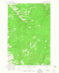
1964 Map of Deer Mountain
USGS Topo · Published 1968About this map
Sleeping Child Hot Springs serves as a focal point for this 1964 survey of the Bitterroot National Forest in Ravalli County. The landscape is defined by the complex drainage systems of Sleeping Child Creek and the North Fork Rye Creek, with numerous named gulches and springs providing vital markers for navigation. The mapping, based on 1963 aerial photography, reveals the early development of Last Log Dr and a network of pack trails that connect the high points of Deer Mountain and Blacktail Point. Features like Hamburger Flat and Cat House Creek reflect the local nomenclature and land use of the mid-20th century, offering a clear record of the area before modern infrastructure altered these mountain corridors.
Find a feature on this map
26 named features on this map. Tap any name to fly to it.
Don’t see what you’re looking for? This feature index may not catch every label — zoom into the map to look around manually.
Map Details
Editions of this 1964 Deer Mountain Map
2 editions found
Other maps of this area

1901 · Hamilton
USGS Topo · 1:125,000

1909 · Sapphire
USGS Topo · 1:125,000

1947 · Butte
USGS Topo · 1:250,000

1955 · Dillon
USGS Topo · 1:250,000

1956 · Elk City
USGS Topo · 1:250,000

1956 · Hamilton
USGS Topo · 1:250,000

1957 · Dillon
USGS Topo · 1:250,000

1958 · Butte
USGS Topo · 1:250,000

1958 · Dillon
USGS Topo · 1:250,000

1959 · Hamilton
USGS Topo · 1:250,000