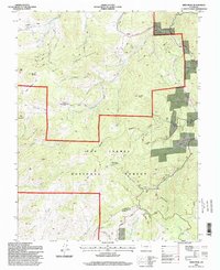
1994 Map of Deer Peak
USGS Topo · Published 1998About this map
San Isabel National Forest encompasses the vast majority of this high-altitude landscape along the border of Custer and Huerfano counties. The terrain is defined by dramatic peaks and divides, including Wixson Mountain and Deer Peak, the latter of which serves as a modern utility hub with the Deer Peak Communication Tower. In the northern reaches, the Frontier Pathways scenic route and the Hardscrabble Byway provide access through the mountain passes near Junkins Park. This 1990s-era survey reveals the persistent imprint of local industry and recreation, from the Abbey Summer Camp in the northeast to the scattered symbols of the region's mining heritage. Numerous labels for Mine, Mines, and Prospect are concentrated around Ophir Gulch and Mammoth Gulch, tracing the historical efforts to extract resources from the steep canyon walls and meadows like Burris Meadow.
Find a feature on this map
52 named features on this map. Tap any name to fly to it.
Don’t see what you’re looking for? This feature index may not catch every label — zoom into the map to look around manually.
Map Details
Editions of this 1994 Deer Peak Map
This is the sole edition of this map. No revisions or reprints were ever made.
Other maps of this area

1889 · Canon City
USGS Topo · 1:125,000

1889 · Huerfano Park
USGS Topo · 1:125,000

1892 · Huerfano Park
USGS Topo · 1:125,000

1892 · Canon City
USGS Topo · 1:125,000

1954 · Mount Tyndall
USGS Topo · 1:24,000

1954 · Rosita
USGS Topo · 1:24,000

1954 · Trinidad
USGS Topo · 1:250,000

1954 · Pueblo
USGS Topo · 1:250,000

1955 · Trinidad
USGS Topo · 1:250,000

1957 · Pueblo
USGS Topo · 1:250,000