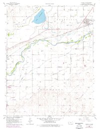
1960 Map of Deerfield
USGS Topo · Published 1978About this map
The Arkansas River valley defines this section of western Kansas, where a sophisticated network of irrigation channels like the Amazon Ditch and Great South Side DITCH supports the local agriculture. The towns of Deerfield and Lakin serve as primary hubs along the Atchison Topeka and Santa Fe railroad, which parallels the river corridor. To the north, Mc Kinney Lake provides a significant water feature in this prairie landscape.
Find a feature on this map
18 named features on this map. Tap any name to fly to it.
Don’t see what you’re looking for? This feature index may not catch every label — zoom into the map to look around manually.
Map Details
Editions of this 1960 Deerfield Map
2 editions found
Other maps of this area

1891 · Larned
USGS Topo · 1:125,000

1900 · Lakin
USGS Topo · 1:125,000

1955 · Dodge City
USGS Topo · 1:250,000

1955 · Scott City
USGS Topo · 1:250,000

1958 · Dodge City
USGS Topo · 1:250,000

1958 · Scott City
USGS Topo · 1:250,000

1959 · Dodge City
USGS Topo · 1:250,000
1960 · Deerfield SE
USGS Topo · 1:24,000
1960 · Deerfield SW
USGS Topo · 1:24,000

1960 · Deerfield
USGS Topo · 1:24,000