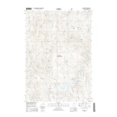
2015 Map of Deerfield
USGS Topo · Published 2015About this map
Deerfield Lake serves as the central focal point of this high-altitude landscape within the Black Hills National Forest. The settlement of Deerfield is positioned along the western edge of the reservoir, where Castle Creek enters the basin. This area is characterized by a complex network of draws, gulches, and springs, including Maitland Spring and Taylor Spring, which provide vital water sources in this elevated environment. Prominent topographical landmarks such as Whitetail Peak, Nipple Butte, and Castle Rock rise above the surrounding terrain, while Reynolds Prairie offers a localized expanse of open ground. The map details an extensive system of forest roads and trails, such as the Whitetail Loop and the N Shore Trail Head, illustrating the modern recreational and resource management infrastructure of the Black Hills.
Find a feature on this map
72 named features on this map. Tap any name to fly to it.
Don’t see what you’re looking for? This feature index may not catch every label — zoom into the map to look around manually.
Map Details
Editions of this 2015 Deerfield Map
This is the sole edition of this map. No revisions or reprints were ever made.
Other maps of this area

1894 · Deadwood
USGS Topo · 1:125,000

1896 · Harney Peak
USGS Topo · 1:125,000

1901 · Harney Peak
USGS Topo · 1:125,000

1901 · Deadwood
USGS Topo · 1:125,000

1916 · Deadwood
USGS Topo · 1:125,000

1953 · Rapid City
USGS Topo · 1:250,000

1955 · Hot Springs
USGS Topo · 1:250,000
1956 · Custer
USGS Topo · 1:62,500
1956 · Crooks Tower
USGS Topo · 1:24,000
1956 · Crows Nest Peak
USGS Topo · 1:24,000