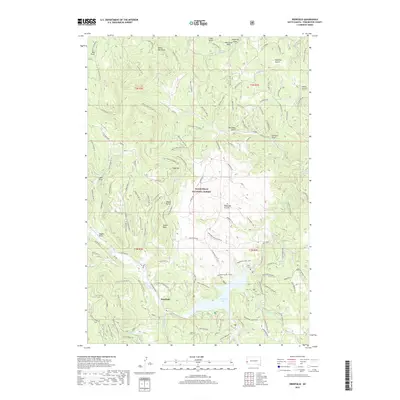
2017 Map of Deerfield
USGS Topo · Published 2017About this map
Deerfield Lake serves as the central focal point for this section of the Black Hills National Forest in Pennington County. The small settlement of Deerfield sits near the western shore of the reservoir, positioned where the S Fork Castle Cr and N Fork Castle Cr once naturally joined to form Castle Cr. The landscape is defined by a series of named draws and gulches, including Smith Gulch and Sawbuck Draw, which drain the surrounding high points. High elevations are marked by distinctive landmarks such as Nipple Butte, White Tail Peak, and Castle Rock. The map illustrates a complex network of forest service roads, such as Rochford Road and Whitetail Peak Rd, which provide access to remote areas like Reynolds Prairie and numerous natural water sources including Maitland Spring and Lyons Spring.
Find a feature on this map
117 named features on this map. Tap any name to fly to it.
Don’t see what you’re looking for? This feature index may not catch every label — zoom into the map to look around manually.
Map Details
Editions of this 2017 Deerfield Map
This is the sole edition of this map. No revisions or reprints were ever made.
Other maps of this area

1894 · Deadwood
USGS Topo · 1:125,000

1896 · Harney Peak
USGS Topo · 1:125,000

1901 · Harney Peak
USGS Topo · 1:125,000

1901 · Deadwood
USGS Topo · 1:125,000

1916 · Deadwood
USGS Topo · 1:125,000

1953 · Rapid City
USGS Topo · 1:250,000

1955 · Hot Springs
USGS Topo · 1:250,000
1956 · Custer
USGS Topo · 1:62,500
1956 · Crooks Tower
USGS Topo · 1:24,000
1956 · Crows Nest Peak
USGS Topo · 1:24,000