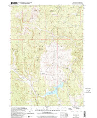
1998 Map of Deerfield
USGS Topo · Published 2001About this map
Deerfield Lake dominates the southern portion of this high-elevation landscape, situated within the expansive Black Hills National Forest. The map documents a rugged drainage network defined by Castle Creek and its many tributaries, including Horsetief Creek and South Fork Creek. Mining activity is a notable historical footprint here, with operations such as the Yellow Bird Mine, King of the West Mine, and Divide Lode Mine concentrated in the northern sections. This late 20th-century update reveals a landscape of working ranches and seasonal camps scattered throughout the forest, including the Lesserring Ranch, Kinney Ranch, and the evocatively named Merry-Go-Round Camp. Educational and civic life is anchored by the Castle Rock Sch near Deerfield, while significant topography like Flag Mountain and White Tail Peak provided vantage points for a Lookout Tower and a Gaging Station used to monitor the region’s vital water resources.
Find a feature on this map
61 named features on this map. Tap any name to fly to it.
Don’t see what you’re looking for? This feature index may not catch every label — zoom into the map to look around manually.
Map Details
Editions of this 1998 Deerfield Map
This is the sole edition of this map. No revisions or reprints were ever made.
Other maps of this area

1894 · Deadwood
USGS Topo · 1:125,000

1896 · Harney Peak
USGS Topo · 1:125,000

1901 · Harney Peak
USGS Topo · 1:125,000

1901 · Deadwood
USGS Topo · 1:125,000

1916 · Deadwood
USGS Topo · 1:125,000

1953 · Rapid City
USGS Topo · 1:250,000

1955 · Hot Springs
USGS Topo · 1:250,000
1956 · Custer
USGS Topo · 1:62,500
1956 · Crooks Tower
USGS Topo · 1:24,000
1956 · Crows Nest Peak
USGS Topo · 1:24,000