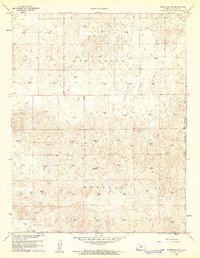
1960 Map of Deerfield SW
USGS Topo · Published 1961About this map
The vast, undulating plains of Kearny County are defined here by the systematic development of the Hugoton natural gas field at the start of the 1960s. Across the townships of South Side and Kendall, the landscape is organized by a geometric grid of sections, each punctuated by numerous industrial sites. The proliferation of the Gas Well across nearly every square mile reveals the intensity of energy extraction during this era, showing how industrial infrastructure integrated with the rural Kansas terrain. Beyond these resource points, the sheet captures a high-plains landscape shaped by depression-like contours and unimproved dirt tracks, reflecting the sparse, utilitarian settlement patterns of the high desert fringe in western Kansas.
Find a feature on this map
3 named features on this map. Tap any name to fly to it.
Don’t see what you’re looking for? This feature index may not catch every label — zoom into the map to look around manually.
Map Details
Editions of this 1960 Deerfield SW Map
2 editions found
Other maps of this area

1891 · Larned
USGS Topo · 1:125,000

1900 · Lakin
USGS Topo · 1:125,000

1955 · Dodge City
USGS Topo · 1:250,000

1958 · Dodge City
USGS Topo · 1:250,000

1959 · Dodge City
USGS Topo · 1:250,000

1959 · Ulysses NE
USGS Topo · 1:24,000

1959 · Hickok NW
USGS Topo · 1:24,000

1959 · Hickok NE
USGS Topo · 1:24,000
1960 · Deerfield SE
USGS Topo · 1:24,000

1960 · Deerfield
USGS Topo · 1:24,000