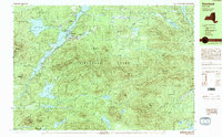
1989 Map of Deerland
USGS Topo · Published 1989About this map
Adirondack Park dominates the landscape of this 1989 provisional survey, centering on the elongated waters of Long Lake and the community of Deerland. The map illustrates a region defined by recreational access and conservation, where the NPT Trail and Snowmobile Trail networks wind through a dense cluster of peaks including Mount Sabattis and Windfall Mountain. In the hamlet of Long Lake, local infrastructure is concentrated around the Post Office and Boat Ramp, marking the junction of road and waterway navigation.
Find a feature on this map
60 named features on this map. Tap any name to fly to it.
Don’t see what you’re looking for? This feature index may not catch every label — zoom into the map to look around manually.
Map Details
Editions of this 1989 Deerland Map
This is the sole edition of this map. No revisions or reprints were ever made.
Other maps of this area

1898 · Newcomb
USGS Topo · 1:62,500

1901 · Newcomb
USGS Topo · 1:62,500

1903 · Raquette Lake
USGS Topo · 1:62,500

1903 · Blue Mountain
USGS Topo · 1:62,500

1904 · Santanoni
USGS Topo · 1:62,500

1904 · Long Lake
USGS Topo · 1:62,500

1907 · Tupper Lake
USGS Topo · 1:62,500

1948 · Ogdensburg
USGS Topo · 1:250,000

1950 · Utica
USGS Topo · 1:250,000

1951 · Ogdensburg
USGS Topo · 1:250,000