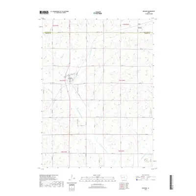
2018 Map of Defiance
USGS Topo · Published 2018About this map
Defiance sits near the western edge of Shelby County, situated along the drainage of the W Fork W Nishnabotna River. The town layout is clearly defined, featuring the local Po and the Union Township Cem just to the west. A network of rural section-line roads, including Linden Rd and Knotty Pine Rd, connects these upland agricultural plains. To the north, across the Crawford Co line, lies the small settlement of Astor, characterized by its own Astor Cem and the Nishnabotna River Bridge. This region is defined by its deep river valleys and small cemeteries, such as Saint Pauls Cem and Slates Cem, which serve as quiet landmarks of the area's ancestral settlement patterns. The landscape is heavily dissected by numerous tributaries, including Kidds Cr and Willow Cr, flowing toward the larger river system.
Find a feature on this map
48 named features on this map. Tap any name to fly to it.
Don’t see what you’re looking for? This feature index may not catch every label — zoom into the map to look around manually.
Map Details
Editions of this 2018 Defiance Map
This is the sole edition of this map. No revisions or reprints were ever made.
Other maps of this area

1954 · Omaha
USGS Topo · 1:250,000

1957 · Omaha
USGS Topo · 1:250,000

1958 · Omaha
USGS Topo · 1:250,000

1971 · Earling
USGS Topo · 1:24,000

1971 · Earling NE
USGS Topo · 1:24,000
1971 · Dow City
USGS Topo · 1:24,000

1971 · Defiance
USGS Topo · 1:24,000

1978 · Panama
USGS Topo · 1:24,000

1978 · Manilla
USGS Topo · 1:24,000

1978 · Irwin
USGS Topo · 1:24,000