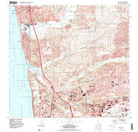
1994 Map of Del Mar
USGS Topo · Published 2000About this map
Solana Beach and Del Mar anchor this coastal survey, where the development of the mid-1990s meets the preserved landscapes of the Torrey Pines State Reserve. The shoreline is defined by the Pacific Ocean and Blacks Beach, while inland, the terrain breaks into a series of canyons such as Gonzales Canyon and McGonigle Canyon. A notable concentration of institutional and recreational landmarks is evident, including the Del Mar Race Track and the Del Mar Fairgrounds, alongside the sprawling academic grounds of the Univ Of Calif San Diego.
Find a feature on this map
53 named features on this map. Tap any name to fly to it.
Don’t see what you’re looking for? This feature index may not catch every label — zoom into the map to look around manually.
Map Details
Editions of this 1994 Del Mar Map
This is the sole edition of this map. No revisions or reprints were ever made.
Other maps of this area

1893 · Oceanside
USGS Topo · 1:62,500

1893 · Escondido
USGS Topo · 1:62,500

1898 · Oceanside
USGS Topo · 1:62,500

1901 · Escondido
USGS Topo · 1:62,500

1901 · Oceanside
USGS Topo · 1:62,500

1901 · San Luis Rey
USGS Topo · 1:125,000

1903 · La Jolla
USGS Topo · 1:62,500

1904 · Southern California Sheet No. 2
USGS Topo · 1:250,000

1930 · La Jolla
USGS Topo · 1:62,500

1942 · Poway Valley
USGS Topo · 1:31,680