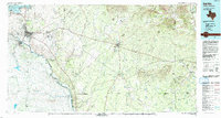
1986 Map of Del Rio
USGS Topo · Published 1993About this map
The Rio Grande serves as the international border on this mid-1980s survey, separating the growing city of Del Rio and the nearby Laughlin Air Force Base from its southern neighbor, Acuña. The landscape transitions from the massive waters of the Amistad Reservoir in the west to the higher elevations of the Anacacho Mountains and Turkey Mountains in the east.
Find a feature on this map
62 named features on this map. Tap any name to fly to it.
Don’t see what you’re looking for? This feature index may not catch every label — zoom into the map to look around manually.
Map Details
Editions of this 1986 Del Rio Map
2 editions found
Other maps of this area

1893 · Nueces
USGS Topo · 1:125,000

1896 · Nueces
USGS Topo · 1:125,000

1896 · Brackett
USGS Topo · 1:125,000

1897 · Brackett
USGS Topo · 1:125,000

1898 · Uvalde
USGS Topo · 1:125,000

1899 · Uvalde
USGS Topo · 1:125,000

1938 · Turkey Mountain
USGS Topo · 1:48,000

1939 · La Pryor
USGS Topo · 1:62,500

1940 · Paloma
USGS Topo · 1:62,500

1940 · Quemado
USGS Topo · 1:62,500