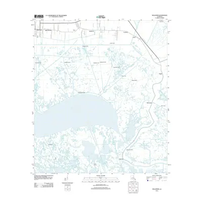
2012 Map of Delacroix
USGS Topo · Published 2012About this map
The low-lying coastal marshes of Saint Bernard Parish dominate this landscape, where land and water are inextricably linked by a dense network of drainage and transport canals. Settlements such as Sebastopol, Saint Bernard, Toca, and Reggio cling to the higher ground along Bayou Rd and the historic Bayou la Loutre corridor. The southern portion of the map transitions into the expansive Lake Lery, bordered by industrial sites like the Lake Lery Gas Field and Bayou Gentilly Gas Field, illustrating the region's reliance on coastal resources.
Find a feature on this map
32 named features on this map. Tap any name to fly to it.
Don’t see what you’re looking for? This feature index may not catch every label — zoom into the map to look around manually.
Map Details
Editions of this 2012 Delacroix Map
This is the sole edition of this map. No revisions or reprints were ever made.
Other maps of this area

1891 · Pointe a La Hache
USGS Topo · 1:62,500

1892 · St. Bernard
USGS Topo · 1:62,500

1892 · Pointe a La Hache
USGS Topo · 1:62,500

1893 · Shell Beach
USGS Topo · 1:62,500

1893 · Dime
USGS Topo · 1:62,500

1935 · Delacroix
USGS Topo · 1:31,680

1935 · Lake Batola
USGS Topo · 1:31,680

1939 · Shell Beach
USGS Topo · 1:62,500
1939 · Chalmette
USGS Topo · 1:31,680

1939 · Pointe a La Hache
USGS Topo · 1:62,500