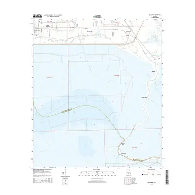
2015 Map of Delacroix
USGS Topo · Published 2015About this map
Saint Bernard and the surrounding coastal communities are defined by a complex network of waterways and drainage canals that reach into the marshlands of southeastern Louisiana. The map reveals the intricate engineering of the landscape, where the Forty Arpent Canal and Eighty Arpent Canal parallel the historic settlement corridor along Bayou Rd. These canals, alongside smaller works like the Creedmore Canal and Whitehall Canal, reflect the ongoing effort to manage the water levels of the delta terrain.
Find a feature on this map
39 named features on this map. Tap any name to fly to it.
Don’t see what you’re looking for? This feature index may not catch every label — zoom into the map to look around manually.
Map Details
Editions of this 2015 Delacroix Map
This is the sole edition of this map. No revisions or reprints were ever made.
Other maps of this area

1891 · Pointe a La Hache
USGS Topo · 1:62,500

1892 · St. Bernard
USGS Topo · 1:62,500

1892 · Pointe a La Hache
USGS Topo · 1:62,500

1893 · Shell Beach
USGS Topo · 1:62,500

1893 · Dime
USGS Topo · 1:62,500

1935 · Delacroix
USGS Topo · 1:31,680

1935 · Lake Batola
USGS Topo · 1:31,680

1939 · Shell Beach
USGS Topo · 1:62,500
1939 · Chalmette
USGS Topo · 1:31,680

1939 · Pointe a La Hache
USGS Topo · 1:62,500