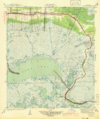
1941 Map of Delacroix
USGS Topo · Published 1941About this map
Delacroix Island and the surrounding marshlands of southeastern Louisiana are defined by a complex network of man-made and natural waterways that shaped life in the early 1940s. The settlement of Delacroix sits at the southern terminus of the road network, which follows the natural levee of the Bayou Terre aux Boeufs. To the north, the communities of Reggio, Verret, Estopinal, Toca, and St Bernard are clustered along this same high ground, which provides a corridor of dry land through the swamp.
Find a feature on this map
22 named features on this map. Tap any name to fly to it.
Don’t see what you’re looking for? This feature index may not catch every label — zoom into the map to look around manually.
Map Details
Editions of this 1941 Delacroix Map
This is the sole edition of this map. No revisions or reprints were ever made.
Other maps of this area

1891 · Pointe a La Hache
USGS Topo · 1:62,500

1892 · St. Bernard
USGS Topo · 1:62,500

1892 · Pointe a La Hache
USGS Topo · 1:62,500

1893 · Shell Beach
USGS Topo · 1:62,500

1893 · Dime
USGS Topo · 1:62,500

1935 · Delacroix
USGS Topo · 1:31,680

1935 · Lake Batola
USGS Topo · 1:31,680

1939 · Shell Beach
USGS Topo · 1:62,500
1939 · Chalmette
USGS Topo · 1:31,680

1939 · Pointe a La Hache
USGS Topo · 1:62,500