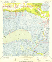
1951 Map of Delacroix
USGS Topo · Published 1952About this map
St Bernard and its surrounding marshlands are documented here just after mid-century, following a culture revision that updated the landscape from earlier 1930s surveys. The map traces the historic ribbon of development along the Bayou and Terre aux Boeufs, where settlements like Verret, Reggio, and Delacroix cling to the high ground of the natural levees. This linear settlement pattern is a hallmark of the region, reflecting the necessity of staying near the bayous for both transportation and arable land.
Find a feature on this map
30 named features on this map. Tap any name to fly to it.
Don’t see what you’re looking for? This feature index may not catch every label — zoom into the map to look around manually.
Map Details
Editions of this 1951 Delacroix Map
This is the sole edition of this map. No revisions or reprints were ever made.
Other maps of this area

1891 · Pointe a La Hache
USGS Topo · 1:62,500

1892 · St. Bernard
USGS Topo · 1:62,500

1892 · Pointe a La Hache
USGS Topo · 1:62,500

1893 · Shell Beach
USGS Topo · 1:62,500

1893 · Dime
USGS Topo · 1:62,500

1935 · Delacroix
USGS Topo · 1:31,680

1935 · Lake Batola
USGS Topo · 1:31,680

1939 · Shell Beach
USGS Topo · 1:62,500
1939 · Chalmette
USGS Topo · 1:31,680

1939 · Pointe a La Hache
USGS Topo · 1:62,500